Hidden deep within the Shi Yomi district (Western Siang region) of Arunachal Pradesh, Mechuka Valley (also known as Menchuka) is one of the most enchanting offbeat destinations in Northeast India. Located near the Indo-China border at an altitude of about 6,000 feet, this Himalayan valley is adorned with rolling meadows, snow-clad peaks, wooden houses, and a glistening river that meanders gracefully through the heart of the valley. The name “Mechuka” literally means “medicinal water of snow,” a nod to the region’s pristine streams and natural springs believed to have healing properties.
Mechuka combines breathtaking natural beauty with an authentic cultural tapestry. The valley is home to the Memba, Ramo, and Bokar tribes (Ramo and Bokar are sub-tribes of Adi Tribe), whose age-old Buddhist traditions, unique wooden architecture, and vibrant festivals lend a timeless charm to the landscape. Often referred to as the "Mini Switzerland of Arunachal Pradesh", Mechuka offers everything — adventure, spirituality, and serenity — making it an unmissable addition to any Northeast India itinerary.
Sightseeing in Mechuka is a harmonious blend of nature, spirituality, and cultural immersion. The valley’s serene environment, surrounded by snow-capped mountains and the shimmering Siyom River, creates an atmosphere of peace and exploration. Every bend in the road reveals wooden bridges, remote monasteries, and postcard-perfect villages that still preserve their traditional ways of life.
Mechuka comes alive with vibrant local events. The Mechuka Trout Fest celebrates the region’s rivers and angling traditions. Adventure enthusiasts can catch the Mechuka Adventure Racing Championship and the Mechuka Mountain Trek Challenge, showcasing thrilling outdoor pursuits amidst stunning landscapes.
Beyond these events, explore nearby gems like Yarlung Village, known for its hot springs, Tato Village with panoramic ridge-top views, and hidden trekking trails leading to remote mountain passes. Visitors also gain authentic cultural insights through interactions with the Memba tribe, famous for their intricate handwoven woolens and warm butter tea hospitality.
Mechuka is connected by road from Aalo (Along), about 180 km away, which in turn connects to Pasighat and Likabali. The drive from Aalo to Mechuka takes around 6–8 hours, passing through dense forests, hanging bridges, and charming tribal villages. Shared SUVs and taxis are available from Aalo.
The nearest airport is Pasighat Airport (IXT), around 300 km away, with limited flights connecting via Guwahati. For better connectivity, most travelers fly into Dibrugarh Airport (DIB) in Assam and continue by road to Mechuka via Aalo.
The nearest major railhead is Silapathar Railway Station in Assam, approximately 400 km from Mechuka. From there, taxis and local transports are available toward Aalo and onward to Mechuka.
Visitors to Mechuka require an Inner Line Permit (ILP) for entry into Arunachal Pradesh. The ILP can be easily obtained online or from offices in Guwahati, Itanagar, or Delhi. Foreign nationals need a Protected Area Permit (PAP) issued by the Ministry of Home Affairs, Government of India. Note: Foreign nationals are not allowed to travel close to the India–China border without special authorization.
click here to apply for online ILP
Mechuka enjoys a cool temperate mountain climate throughout the year, characterized by crisp air, bright skies, and occasional snowfall during winter. Due to its high altitude, temperatures remain pleasant for most of the year, making it a perfect destination for both adventure seekers and those looking to unwind amidst nature.
| Season | Months | Temperature Range | Highlights |
|---|---|---|---|
| Winter | December – February | -5°C – 10°C | Cold and scenic with occasional snowfall; mountain peaks remain snow-covered. Ideal for photography and experiencing the serene, frozen beauty of the valley. |
| Summer | March – June | 10°C – 25°C | Pleasant temperatures, clear skies, and blooming meadows. Perfect for hiking, local exploration, and cultural interactions with the Memba and Ramo tribes. |
| Monsoon | July – September | 12°C – 20°C | Moderate to heavy rainfall; the valley turns lush green and misty. Roads may be challenging, but the landscapes are vibrant and raw for offbeat travelers. |
| Post-Monsoon (Autumn) | October – November | 8°C – 18°C | Clear skies, crisp air, and colorful mountain slopes. The best time to visit for hassle-free travel, sightseeing, and the famous Mechuka Adventure Festival. |
Owing to its altitude, temperatures can drop sharply after sunset even in summer. Visitors should carry light woollens, windproof jackets, sunscreen, and lip balm. During winter, heavy woollens and thermals are essential for comfort and safety.
The best time to visit Mechuka is between October and April when the weather remains stable and the valley is at its most picturesque. Travelers can choose their preferred season based on the type of experience they seek:
Day 1: Dibrugarh → Aalo (Along) via Pasighat
Day 2: Aalo → Mechuka (scenic drive through mountain valleys and wooden bridges)
Day 3: Local sightseeing (Samten Yongcha Monastery, Nanak Taposthan, Hanuman Camp)
Day 4: Explore Dorjeeling and Yarlung villages, interact with local Memba tribes
Day 5: Optional short hikes or attend cultural programs (seasonal festivals)
Day 6: Mechuka → Aalo
Day 7: Aalo → Dibrugarh / Aalo → Pasighat (and further towards Roing to continue a different leg of Eastern Arunachal itineraries)
For detailed itineraries and customizable trip options, check out our Mechuka Tour Packages. Flexible halts and slow-travel options allow visitors to enjoy the valley at a relaxed pace.
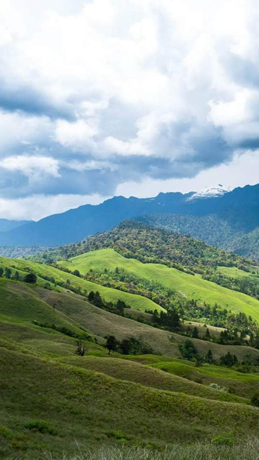
Dorjeeling Village
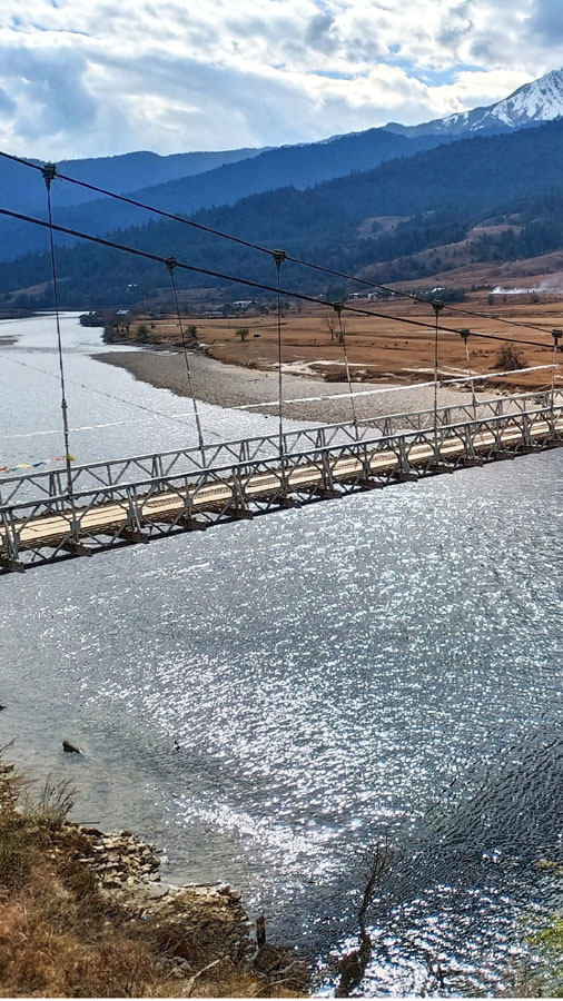
Old suspension Hanging Bridge
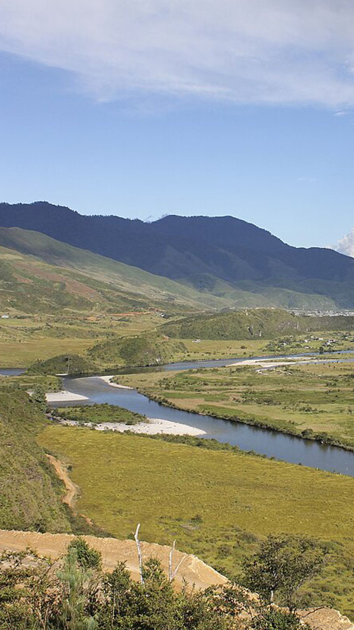
Siyom River
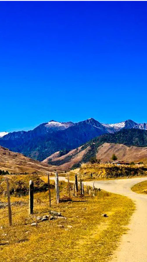
Surrounding View
Mechuka has the longest zipline in the Northeast India, of approximately 800 metres.
The ideal time to visit Mechuka is between October and April. During these months, the weather is pleasant with clear skies, making outdoor activities, trekking, and sightseeing comfortable. Monsoon months are generally avoided due to rainfall and potential landslides.
The name "Mechuka" is derived from the local Memba language, where "Me" means valley and "Chuka" refers to the river that flows through it. The valley’s natural features and river systems have influenced its name for centuries.
Mechuka is home to the Memba and Ramo tribes. The Memba are particularly known for their intricate handwoven woolens, butter tea hospitality, and traditional festivals, while the Ramo maintain agricultural and pastoral traditions.
Yes, the Mechuka Monastery, perched atop a hill and over 400 years old, is the region’s most famous monastery. It predates even the Tawang Monastery and showcases ancient Tibetan Buddhist architecture.
Major local events include the Mechuka Trout Fest, the Mechuka Adventure Racing Championship, and the Mechuka Mountain Trek Challenge. These events combine sports, adventure, and cultural experiences for visitors.
Mechuka is approximately 900 kilometers east of Tawang. The journey passes through scenic mountain roads, including Bomdila, Dirang, Daporijo, Pasighat, and Aalo, offering breathtaking views of the high Himalayas.
Yes, visitors need an Inner Line Permit (ILP), which can be obtained online or at designated offices in Guwahati, Itanagar, or other authorized centers. Foreign nationals will require Protected Area Permit (PAP), and may need additional approvals depending on border proximity.
Mechuka is situated at an altitude of around 6,000 feet (1,800 meters) above sea level, which gives it cool temperatures and crisp mountain air year-round.
Absolutely. The region offers numerous trekking routes, from easy village trails to challenging passes leading into the high Himalayas. Trekking is particularly popular in spring and autumn when weather conditions are favorable.
Yes, local cuisine features butter tea, tsampa, thukpa, and other traditional dishes. Guests often enjoy meals prepared by Memba households, gaining a firsthand experience of authentic flavors.
Yes, the valley is traversed by the Siyom River and several smaller streams. Trout fishing is popular, and some rivers host the Mechuka Trout Fest annually.
Mechuka has rich biodiversity with sightings of Himalayan birds, red pandas, and endemic trout species in rivers. The surrounding forests are also habitats for leopards, bears, and other Himalayan wildlife.
The nearest airport is Pasighat Airport, about 300 kilometers away. Guwahati Airport is the major hub for international and domestic flights, with onward road travel to Mechuka.
Yes, Mechuka has long been a cultural crossroads due to its proximity to Tibet and Bhutan. Ancient trade routes passed through the valley, and monasteries like Mechuka Monastery hold centuries-old manuscripts and thangkas.
Temperatures range from 5°C to 25°C depending on the season. Winter brings cold mornings and occasional frost, while summer is mild and pleasant. Heavy rains can occur during the monsoon months (July–September).
Yes, Mechuka hosts mountain trekking, river fishing, paragliding, and adventure races, making it a hotspot for outdoor enthusiasts seeking high-altitude challenges.
The journey by road from Guwahati takes around 24-30 hours, often split with overnight stops at Dibrugarh and Aalo. Road conditions can vary, especially during the monsoon.
Yes, photography is encouraged—especially of landscapes, monasteries, tribal villages, and festivals. Drone usage may require prior permission from local authorities.
While historically a small valley settlement, Mechuka has gradually developed with eco-resorts, homestays, and small guesthouses, carefully preserving the natural environment and tribal culture.
Local leaders, Buddhist monks, and tribal elders play pivotal roles in preserving Mechuka’s culture and traditions. The monastery heads often guide visitors about religious and cultural practices.
Yes, Mechuka is considered safe and welcoming for solo travelers. Locals are friendly, crime is almost non-existent, and tourism support is growing. However, since the region is remote, solo travelers should inform their accommodation hosts about their itineraries.
Yes, experienced trekkers often explore routes connecting Mechuka to Monigong, Yarlung, and Lamang villages. Longer trails also lead towards the Indo-Tibet border, offering stunning views and camping opportunities.
Mechuka offers eco-resorts, government lodges, budget homestays, and camping sites. Most properties are locally owned, providing a genuine taste of Memba hospitality and homemade food.
Yes, local taxis and SUVs can be hired in Mechuka and Aalo for sightseeing or transfers. However, availability is limited — advance booking is recommended, especially during festivals.
Locals speak Memba, Hindi, and occasional Tibetan dialects. English is understood by many younger residents and guides, especially those involved in tourism.
While both are Buddhist regions, Mechuka is more remote and untouched. It offers fewer crowds, pristine rivers, and closer tribal interactions, compared to Tawang’s larger monasteries and busier tourist flow.
The Mechuka Valley viewpoint, hanging bridge, Samten Yongcha Monastery, and riverside villages are favorite photography spots, especially during sunrise and sunset.
Occasional light snowfall can occur between December and February, especially in upper reaches and nearby ridges, though not as heavy as in Tawang.
Not ideally. The remoteness of Mechuka requires at least 6–7 days for a comfortable trip from Aalo or Pasighat. A weeklong itinerary is recommended for proper exploration.
Yes, the Samten Yongcha Monastery and Dorjeeling Monastery are significant Buddhist sites. Pilgrims often visit these during prayer festivals and full moon observances.
Mobile connectivity in Mechuka is extremely limited. Only BSNL networks occasionally work for voice calls, while internet access is almost non-existent. Most travelers consider this a welcome break — a chance to unplug, disconnect from the digital world, and truly experience Mechuka’s serenity. For essential communication, visitors often check emails once they reach Aalo on their return journey.
Handwoven woolen shawls, bamboo crafts, local honey, and herbal teas are among the most popular souvenirs. Purchases also directly support local artisans and families.
Mechuka is around 180 kilometers from Aalo (about 6–7 hours by road), passing through rugged but scenic terrain.
Warm layers, rain gear, hiking shoes, torchlight, medicines, and power banks are essential. Evenings get cold, and electricity may fluctuate during monsoon.
Yes, camping by the Yargyap Chu River is popular among adventure travelers. Ensure permissions are obtained from local authorities or homestay hosts before setting up tents.
Basic healthcare is available at the Community Health Center in Mechuka. For advanced treatment, travelers may need to visit Aalo or Pasighat.
Yes, the Memba and Ramo tribes continue many ancestral customs — from wool weaving and butter tea to wooden architecture and community prayers.
Trekking, mountain biking, trout fishing, and adventure racing form the core of Mechuka’s outdoor tourism. Events like the Mechuka Adventure Race draw participants from across India.
Roads are being upgraded under BRO supervision. The stretch between Aalo and Mechuka is rugged but motorable year-round except during heavy rains.
Absolutely. Even without trekking, visitors can enjoy scenic drives, monastery visits, village interactions, and peaceful stays amidst untouched nature.
Mechuka’s remoteness makes it one of India’s last true digital detox destinations. With no mobile internet, minimal commercial noise, and no distractions, travelers can fully immerse in nature, meditation, reading, and genuine human connection. The clean mountain air, rhythmic sound of rivers, and absence of constant notifications make it an ideal place to reset the mind, declutter thoughts, and reconnect with oneself.